Elections: Difference between revisions
Jump to navigation
Jump to search
(Added elections page) |
No edit summary |
||
| Line 2: | Line 2: | ||
It is interesting to see that the area unlike the rest of the county, Millhousen and/or Marion Township voted for members of the Democratic party for some time. | It is interesting to see that the area unlike the rest of the county, Millhousen and/or Marion Township voted for members of the Democratic party for some time. | ||
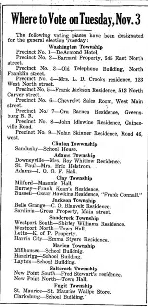
[[File:Election 1936 Polling Places.jpg|thumb|Decatur County Polling Locations in 1936. Layton and Hazelrigg were located on present-day 400 S, between 60 E and US 421<ref>[http://www.historicmapworks.com/Overlay/?m=178149&c=US Decatur County 1882 Atlas, JH Beers & Co.]</ref>]] | |||
[[File:Election 1936.jpg|frameless|1043x1043px]] | [[File:Election 1936.jpg|frameless|1043x1043px]] | ||
Revision as of 19:43, 18 April 2022
Below are some election breakdowns of the Decatur County vote in presidential elections as posted in the Greensburg Daily News.
It is interesting to see that the area unlike the rest of the county, Millhousen and/or Marion Township voted for members of the Democratic party for some time.

Decatur County Polling Locations in 1936. Layton and Hazelrigg were located on present-day 400 S, between 60 E and US 421[1]


